


Maine Lighthouses Illustrated Folded Map and Guide Costal u New Hampshire New Br
$17
Size
Like and save for later
Add To Bundle
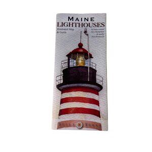
Discover the Maine Lighthouses Illustrated Folded Map and Guide. This atlas-style, paper map features lighthouses in coastal New Hampshire and New Brunswick, presented by the reputable Maine brand.
• Atlas-style folded map
• Material: Paper
• Features Maine lighthouses
• Covers coastal New Hampshire and New Brunswick
• From the reputed Maine brand
Features:
• Includes - One Folded Map
• Detailed shaded relief map of the Maine coast, with new cartography
• 35 original watercolor illustrations
• Locations of all 85 standing and "lost" lighthouses in Maine, coastal New Hampshire & nearby New Brunswick
• History & description of each lighthouse
• Folding Map, Atlas
• Made in United States
• Directions to view each standing light
• Locations & directory of 38 Lighthouse & Maritime Museums
• Directory of 65 Lighthouse Cruises & Island Ferries
• True Tales of Maine lighthouses
• Publisher - Bella Terra Maps
• UPC - 9781888216288
Measurements:
Open Length 36 in / 91 cm
Open Width 24 in / 61 cm
Folded Length 9 in / 23 cm
Folded With 4 in / 10 cm
Condition: Pre-Owned Good
Excellent Condition, No Flaws, You Get What You See In the Photos
Stored in Pet/Smoke-Free Environment
SHIPS SAME DAY/NEXT DAY
We Consider FAIR Offers
Shipping/Discount
Posh Protect: Buyer Protection Policy
Get your order as described or receive your money back. Learn More.


Find Similar Listings
About the seller

@pccloset
Last Active: Jun 23
Orlando, FL
3398
Listings400+
Sold Listings1 day
Avg. Ship time60
Love NotesAbout the seller
@pccloset
Last Active: Jun 23
Orlando, FL
