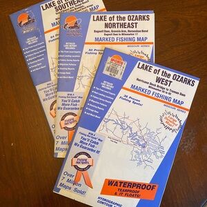


Lake of the Ozarks Marked Fishing Map 1992 Set: west northeast and southeast
$18 $21
Size
Like and save for later
Add To Bundle
Lake of the Ozarks Marked Fishing Map 1992 Set: west northeast and southeast
Set of three waterproof and tear proof fishing maps for Lake of the Ozarks. Each covers a region: West, Northeast, and Southeast. Large detailed map is 24“ x 34“ and provides maps and information on both sides. Each is the 1992 edition printed by Fishing Hotspots Inc. The west is map number M408. The southeast is map number M406 and the northeast is map number M407. Great as a gift for the angler in your life, suitable for display and framing.
Each map gives detailed information on large scale maps that are easy to read and feature fishing holes marked by local experts and guides of the time. The maps also include a detailed report with information on boat landing locations, stocking, fishery survey results, and proven tips and techniques from the times.
Pre-owned in very good condition.
Shipping/Discount
Posh Protect: Buyer Protection Policy
Get your order as described or receive your money back. Learn More.

sandwend
likes this


Find Similar Listings
About the seller

@lwilson29
Last Active: hours ago
Davenport, IA
794
Listings400+
Sold Listings1 day
Avg. Ship time67
Love NotesAbout the seller
@lwilson29
Last Active: hours ago
Davenport, IA
